Tampa: Could this be the one?
- WATCHES & WARNINGS EXTENDED NORTH ON EAST & WEST FL COASTS.
- MULTI-CITY LANDFALL on Florida's west coast while areas of east and Space coast receive 100 mph winds. The Nature and Gold coast cities likely to see winds of 100-120 mph include Naples, Fort Myers, Port Charlotte, Sarasota,Tampa-St. Petersburg, Clearwater.
- 3/ 4 of FLORIDA PENINSULA likely to receive winds 75 mph or greater, per NOAA.
- FORECAST POSITION: NORTH TAMPA METRO BY 4 AM MONDAY AS CAT 3.
- SUMMARY OF OFFICIAL DETAILS: See our Hurricane 411 Center.

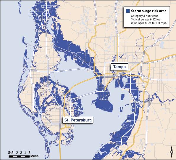
6:00 AM ET SAT 9/9 Westward shift in track took place overnight as has been the trend, resembling the scenarios early this week of a west coast landfall as a major Category 4. These impacts would mirror the 1935 Labor Day Hurricane, 1960 Hurricane Donna and Tampa's last major direct hit in 1921 (1-min video) that produced 6-12 feet of surge in the Bay. View Surge Maps for Tampa inundation levels at Category 3, 4 and 5.
Below is the forecast position for 4 AM Monday 9/11 by the European, of which NHC has indicated their path is mirroring. A docu-drama video scenario developed by the Tampa Bay Catastrophic Plan Project shows how a Category 5 strike would play out were that to occur. Even if not a Cat 5 at landfall, it won't matter. Impacts from this path would essentially be the worse case scenario if the storm restrengthens after leaving Cuba.

What this map means:
- A Category 3 hurricane with 120 mph winds channels directly through Tampa Bay
- Previous 175 miles of coastline and interior sections of West Florida will have just experienced a Category 4 storm with damage far exceeding Donna and the 1935 storm.
9:50 PM ET FRI 9/8 If major westward shifts occur in the official track at this point, Tampa-St. Petersburg could be looking at "the one" they've been fearing for years...a Category 3/4 monster with a 12 foot+ storm surge that inundates the entire downtown and leaves St. Petersburg an island.

The storm surge scenario has been well-researched for years and widely available through the region. Why would it be the absolute worse case scenario? Simply, it's the orientation of this projected path in relation to the coastline:
1. A major hurricane approaching a highly populated coast at an angle
2. A wide mouthed bay which will funnel surge waters far upstream, flooding small inlets already overwhelmed by 6-12 inches of rain that fell in advance of the storm.
3. A northward moving storm that tracks just outside the affected Bay area, giving it maximum exposure to the dangerous right front quadrant of the storm. the portion of the storm with strongest winds & highest surge.
A built-in even worse situation could be that frictional effects due to land interaction of the NE quadrant cause onshore winds to weaken slightly.
- Offshore winds end up being slightly stronger, and this drives the storm in a little sooner than expected.
- Remember Hurricane Charley in 2004? Residents in Punta Gorda were under a hurricane warning, but saw that the projected path was going to take the storm more towards Tampa Bay, a considerable distance NORTH of Charlotte Harbor.
- They considered themselves lucky to have survived a near-miss. In the space of just 4 hours, frictional effects of the storm interacting with land changed it's path, and Charley charged right up the Harbor as a Category 4 monster.
- If that scenario played out with Irma, the damage would be far more catastrophic due to the increased density of people, and the wide circumference of the storm.

The graphic below is an interactive scenario of the flooding potential for Tampa Bay in Category 3, 4, and 5 land-falling hurricanes, created by environmentaldefense.org.