
The last time this happened...
(in 2007) it did not end well.

Solutions over problems
or as Luke Skywalker has said,
"this (winter) is not going to go the way you think!"
 image credit: inverse.com
Special Message From The Team
THE GOOD NEWS?
(in 2007) it did not end well.
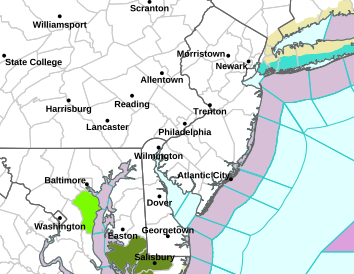
5:30 AM Fri 12/15 - Winter Weather Advisories are posted for portions of the DC-Baltimore-Philadelphia metro regions starting at 1 PM.
With road, air and upper level temperatures all in cold tandem, it is highly probable that any precipitation this afternoon in these regions will:
- Fall as fine-grained snowflakes and freeze on contact with the surface;
- Produce slippery road conditions within 30-60 mins of snow onset;
- Cause widespread hazards during the afternoon and evening commute;
Today may be the first time since February 2007 the Baltimore region faces a decision on whether to wait for "ground truth" or pre-empt the weather with pre-announcements on the afternoon schedule. We were there for that event, and it did not go well for anyone reading this page. The comments from 10 years ago tell the story.
GFS model precip projection for 7 PM tonight.
Solutions over problems
or as Luke Skywalker has said,
"this (winter) is not going to go the way you think!"
(Dec 14 - Dundalk, MD) If you happen to be a Powderhound, a Star Wars--ian, AND perhaps even a student or a teacher, then WHAT an opening day this is turning out to be!?! Is it a sign of things to come for the winter ahead? Or acceptance of one truth: It's time for La Nina winters to end?
THE SHORT LIST: A situation we see unfolding into January for the Mid-Atlantic:
- Extensive December cold & snow not seen in the eastern Mid-Atlantic this month for several years could lead to a reversal in January. Cold in the East may shift to the Midwest and Upper Plains, building snowcover in those areas, leaving eastern Powderhounds behind to watch.
- Two recent snow events in the East have shown us that injecting limited moisture at the right time, with a dry ground and dry air, can produce heavier snow amounts than one might think.
THE ANALYSIS: Why it may not go the way you think.
1) ON TIME COLD: This December is the first time 2011 or 2012 that actual notable cold showed up when it is normally expected to occur, say, around the time winter starts.
- Remember 2 years back, when it was WARMER at Christmas than Thanksgiving? For the 2017-18 winter rodeo, we have back in the saddle a slightly higher coverage of northern snowfall and wider extent of Arctic sea ice for this time of year than in perhaps 5 years.
- I worked at UPS for several years recently in the Baltimore region. During peak season, loaders begin at 12:30 AM sorting your packages. With online ordering this season up 18% from last year, any ounce of snow in the supply chain is very unwelcome.

- It could slow down arrival of the next day's sort, and blow up all your hopes and dreams of receiving that magical item before 12/24. So if you see your loader or driver, take them some cocoa, or soda, or caffeine pills, and pray for an uneventful next 10 days. Because a calm December = on time deliveries.
- If we pile on too much cold too early in one part of the country, as evidenced by the snowcover map, a reversal of fortunes will be in order.
- The gap in snowcover seen in the Midwest and Upper plains? That area will take center stage, with eastern snow disappearing and western snow building up.
- What may look like a slam dunk winter of multiple snowy days may be a weather ruse. If January under-performs in the East, the plot twist we know you're waiting for might be the most interesting of all:

A frigid December, then a mild January, could turn the forces of Canadian cold back to the Powderhound side... with February having a decent chance at a winter finale we've not seen in a long time. Let us know what you think, just don't reveal any Jedi spoilers until we have had the chance to see the big reveal this weekend.
Special Message From The Team
THE GOOD NEWS?
We're back! We haven't forgotten about you, or winter.
In fact, it's snowing quite notably right now at FF HQ.
In fact, it's snowing quite notably right now at FF HQ.
THE BAD NEWS?
La Nina winters usually produce more frustration than accumulation,
at least in the mid-Atlantic.
at least in the mid-Atlantic.
A special message from the team:
- Thank you to all the many well-wishers, supporters and those with concern about the next steps with this website and our organization. Your outreach has been heard and was not ignored.
- Presently, the increasing pace of change within our professional capacities unrelated to weather or climate is a new challenge requiring new solutions.
- We chose to step back for a period of time and evaluate best paths forward that would keep our many loyal readers in the loop, while supporting our families, the needs of students entrusted to our care, and the clients with which we partner during times of critical weather.
- A new update regarding the weather pattern heading into the holidays is in progress for this evening (as in December 13, 2017). Check back tonight or early Thursday morning for expanded details from the good ol' Foots you knew once before... and thanks for being there!
Our sincere (and wintry) regards to you and your family,
Mr. Foot and the FF Team