
"Do you remember the time?"
- Micheal Jackson in the 1991 hit single Remember The Time
5:30 AM ET Fri 3/16 - With the supposed "last storm of the season" earlier this week failing to turn us into believers for one more snow, maybe you're ready to write this winter off, having dealt with enough disappointment thus far.
That's part of the grand curse of a La Nina March: Cold at the wrong time, rain changing to snow, wind that won't leave. It's like being a senior official in the Executive branch: You don't know what's going to happen next, better check Twitter to see about the weather... or maybe your job.
In the Mid-Atlantic, we remember the time when:
- Snowfall occurred during the regular winter season (say, between December 1 and March 15)
- March was sometimes cold and windy. but usually got warmer as the month went on.
- Snow days somehow managed to take place before winter had officially ended.
But now, when looking at the Day 5-6-7 projections, we don't know whether to laugh or cry.
- The NWS Weather Prediction Center in College Park, MD shows a 25-50% chance of potentially significant snow/sleet for a majority of the Mid-Atlantic and Northeast starting next Tuesday extending into Thursday. These maps are probability of liquid equivalent in that time frame, which is pretty high for being this far out in time.

- We don't remember a time this season when two of the biggest and most oft-cited weather computer models (the European and the U.S. Global Forecast System) were in general agreement for a potentially-long duration coastal precipitation event. Below is the GFS operational map for 8 AM next Wed 3/21. European shows a Low in almost exactly the same spot off Norfolk VA at nearly the same pressure.

- Some remember the last time something like this occurred so late in the season: All the way back in March 1958. We can laugh about the possibility, but you might end up crying if you had to to clear 4 feet of heavy wet snow after winter had already ended!
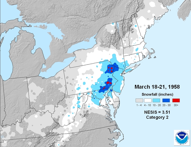
(Below: March 1958 storm in southern PA)

- Winter Stormcast Team of Foot's Forecast