"Here's to the ones who dream..."
- Mia in La La Land, played by Emma Stone
5:30 AM ET THU 12/6/18 - UPDATE
- INFLUENCE OF HIGH PRESSURE OVER THE NORTHEASTERN STATES THIS WEEKEND ON A SOON-TO-DEVELOP SOUTHERN WINTER STORM LIKELY TO KEEP MOST PRECIPITATION SOUTH OF THE D.C./I-66 CORRIDOR.
- INCREASING POTENTIAL FOR HEAVIEST SNOW TO IMPACT SOUTHERN VIRGINIA TO NORTH CAROLINA SUNDAY INTO MONDAY.
- PERIODS OF OCCASIONAL LIGHT SNOW POSSIBLE SUNDAY IN AREAS FROM D.C. METRO NORTH TO BALTIMORE REGION & MD/PA LINE. LOW CONFIDENCE THIS SNOWFALL PRODUCES ANY NOTABLE ACCUMULATION.
|
An upgraded version of the U.S. Global Forecast System, known as the GFS-FV3 model, depicts the positioning of a northern High with the southern Low as favorable for major snow in the Carolinas, but not the Mid-Atlantic. This image is for 2 PM Sunday.
|
SITUATION OVERVIEW: Have you been sniffing around for an indication of what dreams - or nightmares - may be coming this weekend? We thought you might, so our team has updated this current round of statements and scenarios for what is shaping up to be a real knockout storm for the Carolinas & southern Virginia -- and most likely a watch-and-weep event for the northern Mid-Atlantic.
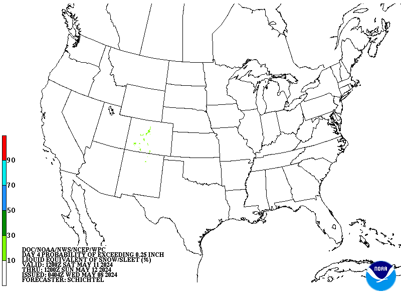
The map above shows probability of 0.25" or more of liquid equivalent frozen precipitation in the "Day 4" period, which as of today would be Sunday morning into Monday morning. As snow fans can see, the areas of highest probability are centered in the Carolinas.
WHAT ARE THE NEW SCENARIOS?
- OPTION A - ALMOST BUT NO (70%) Strength and influence of an approaching Canadian High pressure system counteracts the developing storm as it moves from the southern Plains to the Carolina coast. Most precipitation is kept south of the Mid-Atlantic, with central Virginia seeing light to moderate snow and flurries at most for Washington, D.C. Significant to heavy snow would impact most of the Carolinas. The model outputs for this scenario are based on trends the past few days from the U.S. Global Forecast System (GFS) and it's ensemble means.
- OPTION B - BIG KAHUNA SURPRISE (20%) In FF Lore going back 15 years on this site, a "Big Kahuna" is classified as a high impact major winter storm of primarily snow, with wide-ranging effects extending from coastal areas to the I-95 metro corridor to the Piedmont / Appalachian region. This scenario would be reminiscent of several infamous storms of yesteryear, such as February 17, 2003 or January 30, 2010. Both were modeled to remain south of D.C. Both changed course in the final 6 hours and plowed all the way to central PA with 6-12" or more. The model putputs most closely matching this idea are the GGEM and Canadian.
- OPTION C - COASTAL C-C-CRAWLER (10%) High pressure in southern Canada moving to eastern New England provides a modifying supply of cold air, starting as a dry continental air mass, then morphing into a more most, coastal version. The southern system moves to position off the Outer Banks and stalls or moves very slowly northeast. Precipitation could start as snow along I-95, then change to sleet or freezing rain as the system starts to approach the coast. Timing would slow down to impacts being felt Sunday into Monday or even Tuesday, with earlier outputs of the European model outputs showing this, which has backed off since then, hence our lowered probability.
WHAT'S NEXT?
- We will continue monitoring any hiccups in the model trends in the event a surprise begins brewing for Powderhounds. That's another way of rephrasing the headline to say, your best bet may be to just keep dreaming.
-FF Winter Stormcast Team, contributing to this report:
Forecasters Foot, Jeff W., Jason M. and Keith K.


